
Map of Italy
The geography of Italy and the variety of culture throughout
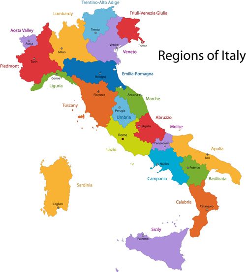
The country is shaped like a boot, with the Adriatic Sea to the east, the Mediterranean Sea to the south, and the Tyrrhenian Sea to the west.Regions of Italy
Each of Italy’s twenty regions has its own unique culture, traditions, and typical dishes. The capital city of Italy is Rome, which is also the largest city in the country.The other major cities in Italy include Milan, Naples, Turin, and Florence.
Stunning mountain ranges, picturesque lakes, and rich culture can be found in the northern parts of Italy. The north includes regions such as Lombardy, Veneto, Emilia-Romagna, and Piedmont.
Lombardy is known for its fashion, finance, and industry, while Veneto is known for its wine, food, and art.
Emilia-Romagna is home to some of the best Italian food, including Parmesan cheese, prosciutto, and balsamic vinegar, while Piedmont is known for its truffles and Barolo wine.
Famous landmarks such as the Colosseum and the Tower of Pisa are located in Central Italy, which also includes Tuscany, Umbria, Marche, and Lazio.
Tuscany has picturesque landscapes, beautiful hilltop towns, and art, including the works of Leonardo da Vinci and Michelangelo.
Umbria is made up of beautiful medieval hill towns, while Marche has incredible beaches and pristine countryside. Lazio is where Rome lies, with its ancient ruins, historical architecture, and world- renowned cuisine.
The coastlines, islands, and rich cultural heritage of Southern Italy are also recognized around the world. The region includes Campania, Calabria, Apulia, and Sicily.
In Campania you can discover the Amalfi Coast, Naples, and Pompeii. Calabria’s landscape is made up of dazzling beaches and rugged mountains, while Apulia is known for its delicious food and spectacular coastline.
Sicily, the largest island in the Mediterranean, is known for its history, architecture, and beaches. Sardinia is another island in Southern Italy. It has crystal clear waters, and unique mountains.
Italy is also recognized for its delicious cuisine, which varies from region to region. Some of Italy's most famous dishes include pizza, pasta, risotto, and gelato.
Each region has its own culinary specialties, such as pesto in Liguria, lasagna in Emilia-Romagna, and Neapolitan pizza in Campania.
With its 20 regions and stunning islands, Italy has something to offer every traveler.
History of the Map of Italy
The history of the map of Italy dates back to ancient times when the practice of cartography was in its early stages.The first known maps of Italy were created by ancient Greek and Roman geographers, who depicted the Italian peninsula as a series of islands surrounded by the Mediterranean Sea.
During the Middle Ages, maps were mainly for religious and political purposes. Numerous maps were made to show the location of important religious sites, such as churches, monasteries, and pilgrimage routes.
Political maps were also important to show the boundaries of different states and kingdoms that ruled Italy at the time.
One of the most famous medieval maps of Italy is the "Tabula Peutingeriana," a large parchment map that depicts the Roman Empire's road network.
The map dates back to 400 AD and was copied and updated over the centuries. It was rediscovered in the 15th century and became an essential tool for travelers and merchants.
During the Renaissance, Italian cartography experienced a significant development with the invention of new techniques and instruments, such as the astrolabe, the compass, and the cross-staff.
The famous cartographer, Paolo dal Pozzo Toscanelli, created a map of the world in the 15th century that included the American continent, which was later used by Christopher Columbus to navigate to the New World.
In the 16th century, Italian cartographers became known for their detailed and accurate maps of Italy.
One of the most famous maps of Italy from this period is the "Lafreri Atlas," created by Antonio Lafreri in Rome. The atlas included maps of different regions of Italy, as well as maps of other parts of the world.
During the 18th and 19th centuries, Italy went through significant political changes, with different states and kingdoms merging and separating.
Maps of Italy became essential tools for politicians, diplomats, and military strategists. They were used to show the boundaries of different states, the location of important cities and towns, and the topography of different regions.
From ancient Greek and Roman geographers to modern digital maps, the cartography of Italy has evolved over time, reflecting the relatively small European country's long history, contributions to culture, and very special geography.


Latest What's on


Latest classifieds


Mattress and mattress cover washable 200x140 cm

Equestrian jacket woman's size 42